| ? Town ? | |
|
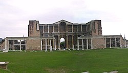
Remains of Sardes (modern-day Sart), the ancient capital of Lydia, slightly outside Salihli |
The city of Salihli, the seat of the district, is located on İzmir-Ankara (E 96) highway and the parallel railway connections. The urban zone is situated on the slopes of Bozdağ mountain chain along the southern alluvial plains of the Gediz River. To the north and northeast of the plain extend two other mountain ranges, respectively those of the mounts Dibek (highest altitude 1.120 m) and Üşümüş (highest altitude 1085 m).
The town lies at an altitude of 125 meters from the sea level. Its advantageous location, smooth and busy intercity connections and the fertile soil allowed Salihli to develop extremely well in recent past.
Four streams, namely Alaşehir, Gümüş, Kurşunlu and Sart cross the district area to join the River Gediz, which flows westward. The climate type is Mediterranean climate. To the 24 km (15 mi) north of the city is Demirköprü Dam, used for irrigation, prevention of overflows, energy production and fishing, and which was built between 1954 and 1960.
The population figures in the 2000 census were 149,150 for the whole district and 83,137 for the urban center of Salihli.
|
Location of Salihli within Turkey. |
Aside from the city of Salihli, the district counts 8 townships with own municipalities. These are (Adala, Durasıllı, Gökeyüp, Mersinli, Poyrazdamları, Sart, Taytan and Yılmaz). Of these Sart corresponds to the location of ancient Sardes, the capital of Lydia.
The district area is surrounded by the neighboring districts of Ahmetli to the west, Gölmarmarato the northwest, Gördes and Köprübaşı to the north, Demirci to the northeast, Kula to the east, Alaşehir to the southeast and Ödemiş to the south.
The distances from Salihli to the seat of neighboring provinces are as follows:
| in km | Manisa | İzmir | Balıkesir | Uşak | Denizli |
| Salihli | 72 | 96 | 144 | 120 | 110 |


